Using panoramic cameras to collect ultra-large-scale spatial data
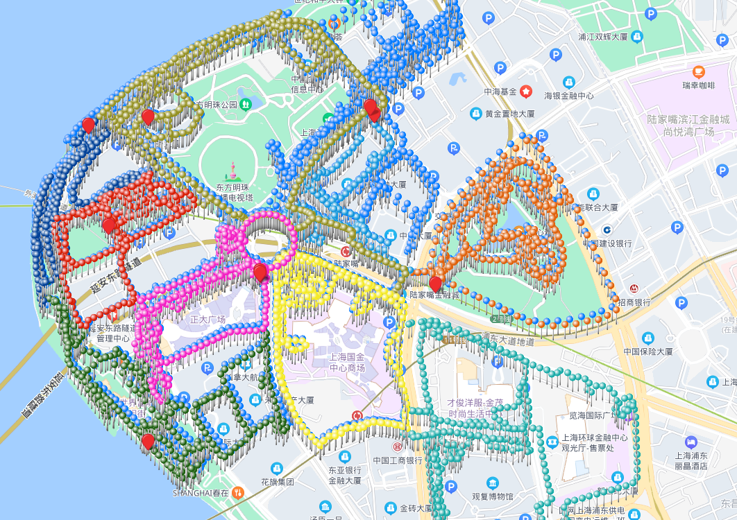
For super-large scenes such as tourist attractions, urban blocks, and large commercial complexes covering areas exceeding hundreds of thousands of square meters or even millions of square meters, single collection sessions or single large maps cannot meet requirements. Therefore, Mega provides city-scale ultra-large-scale spatial multi-map fusion functionality. Using this feature can break through original spatial usage limitations, enabling city-scale VPS positioning.
It is recommended to use the multi-map fusion function when the entire continuous space cannot be fully collected within a 2-hour duration.
Note
This feature requires developers to apply through business channels. We will unlock fusion mapping permissions based on project needs.
By default, Mega only supports fusion mapping for 5 sub-regions. To fuse larger areas, please also apply through business channels.
Solution
The standard solution for ultra-large spaces is divide and conquer. Logically divide the entire large scene into multiple physically overlapping sub-regions, collect each sub-region separately, and finally fuse and optimize all sub-regions. This enables seamless roaming at runtime through dynamic loading.
Acquisition planning
- Divide large scenes by area, scene, or functional zones, with each region covering no more than
100,000 square meters. - Adjacent sub-regions must have at least
200 metersof completely overlapping paths. Larger overlap areas yield better fused maps. Ensure sufficient overlap to optimize adjacent sub-map fusion. - Select texture-rich areas; avoid large expanses of white walls, glass, forests, etc.
- Ensure identical acquisition routes in overlapping paths, including direction and specific routes. Simply put: retrace previous collection paths without deviation.
- Complete adjacent sub-region collections during similar time periods to avoid significant lighting differences (e.g., noon vs. dusk), which may cause fusion failure.
- For multi-floor indoor-outdoor scenes, consider grouping "outdoor + ground floor indoor" as one collection unit and "entire indoor floors" as another. Establish spatial connections through the ground floor's common areas to fuse into a unified large-scale scene map.
Acquisition requirements
Use GoPro Max/Max2 panoramic cameras for ultra-large space collection to ensure data quality and stitching efficiency.
- Each sub-region requires separate route planning
- Configure GoPro Max or GoPro Max2
- Follow single-map acquisition requirements during collection
- Verify compliance with requirements before/during collection using the checklist
Next steps
- If using Mega mapping for the first time, first create a new mapping project
- In Mega Developer Center, create an ultra-large-scale multi-map fusion task. Upload segmented collection videos, and cloud-based mapping algorithms will automatically stitch and optimize them.