Collecting changed areas for incremental update
This chapter introduces how to use panoramic cameras to collect change data for incremental mapping, enabling partial updates to areas with scene changes.
Note
Mega incremental update data collection currently only supports GoPro Max/Max2 cameras. Collection with other brands of panoramic cameras is not yet supported.
Preparations
Read the Mega user guide.
Read the introduction to incremental update to understand the basic principles of incremental mapping.
Refer to GoPro Max configuration to set parameters for the GoPro Max panoramic camera.
Refer to GoPro Max2 configuration to set parameters for the GoPro Max2 panoramic camera.
Clearly define the scope that needs to be collected and updated.
Incremental update data collection route planning
Similar to route planning required before Mega panoramic data mapping collection, pre-planning routes is also necessary before collecting incremental update data.
The overall principle for incremental update route planning is: cover the update area while collecting sufficient unchanged areas from the existing map. Generally, the incremental update collection route must have at least 20 meters of trajectory that simultaneously satisfies:
- Overlapping with the existing map collection path.
- The environment during incremental update is basically consistent with that during the original map collection.
Below are several typical incremental update usage scenarios and corresponding route planning methods.
Partial areas
along the original trajectoryrequire updatingThe dotted line in the figure below represents the original collection trajectory, where area
Cneeds updating, and other areas remain unchanged. During collection, maintain the previous route while collecting areasBandDadjacent to the update areaC, as shown by the solid green line.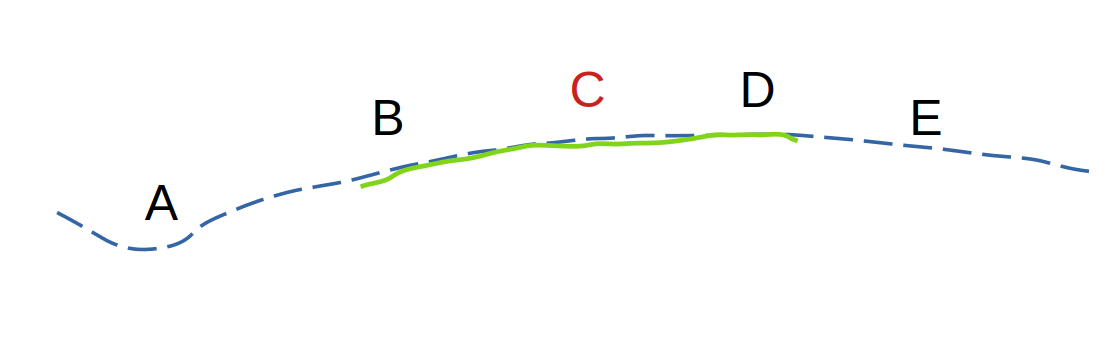
Areas
adjacent to but outside the original trajectoryrequire updatingThe dotted line in the figure below represents the original collection trajectory, where areas
EandFneed updating, and other areas remain unchanged. During supplementary collection, maintain the previous route while collecting adjacent areasCandDnear the update areasEandF, as shown by the solid green line. Start and end the collection in unchanged areasCandD.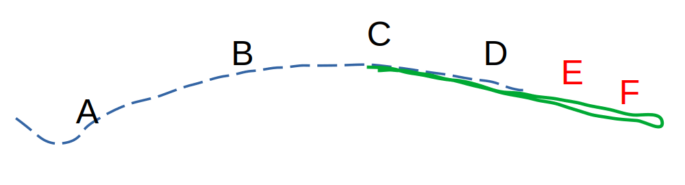
Areas
disconnected from and outside the original trajectoryrequire updatingThe dotted line in the figure below represents the original collection trajectory, where areas
EandFneed updating, and other areas remain unchanged. During supplementary collection, maintain the previous route while collecting adjacent areasCandDnear the update areasEandF, as shown by the solid green line. Start and end the collection in unchanged areasCandD.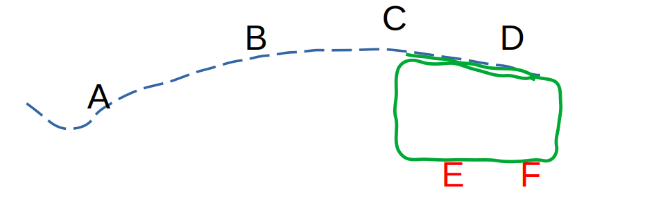
Note
A single incremental update collection session must not exceed 16 minutes. Do not exceed this limit when planning the route.
Starting collection
Check the GoPro Max/Max2 setup checklist to confirm settings meet requirements.
Confirm collection conditions
Avoid collecting when there are many people around.
Avoid collecting during periods of intense lighting (e.g., around noon on sunny days).
Avoid collecting on rainy, snowy, or foggy days.
Power on and prepare
Power on and check the GoPro Max/Max2 camera.
Securelymount the camera onto the selfie stick, with the screen side facing yourself.Ensure there are near-field objects like buildings or statues within 3 meters of the starting point. Avoid starting in the middle of large open squares.
If the route
includes outdoor areas, power on the camera in an open outdoor area first, let it idle forover 2 minutes, then proceed to the starting point to begin collection.
Begin collection
Hold the panoramic camera approximately 20 cm above your head—not too high or too low—keeping the selfie stick vertical.
Press the record button or use the GoPro Quik APP to start recording.
At the starting point, move horizontally over 2 meters while facing a nearby building or wall with rich textures.
During collection
Hold the selfie stick firmly throughout the collection process, keeping the camera as stable as possible.
Walking speed should not exceed 1 meter per second.
Avoid rapid movement. Do not run, cycle, or collect from a moving vehicle.When turning or making U-turns,
reduce turning speedto avoid rapid rotation.Watch out for obstacles. Indoors, be mindful of ceiling height to prevent bumping or scraping the camera.
Monitor collection duration. A single incremental update session
must not exceed 16 minutes.
Ending collection
After collection ends, stop recording by pressing the record button or via the GoPro Quik APP. Wait for
storage to complete.Check that the video duration saved by the camera matches the actual collection time.
Avoiding invalid collection data
Non-standard collection may result in invalid data—meaning the collected data is unusable. Common causes include the following. Please avoid them, and re-collect if encountered.
❌ Forgot to remove the lens protector, including transparent protectors.
❌ Abnormal stop of recording, e.g., camera battery depletion, storage card full, or camera overheating and auto-shutdown.
❌ Camera bumped during collection, e.g., hit a door frame or beam.
❌ Camera fell or slipped off the selfie stick during collection.
❌ Removed the camera during collection to wipe the lens.
❌ Non-standard collection methods like cycling, holding an umbrella, or collecting from a boat.
❌ Selfie stick not kept vertical during collection, e.g., leaned against the body.
Next steps
After completing incremental update panoramic data collection,
- Refer to the panoramic camera data export guide to export your collected data.
- Refer to the incremental mapping operation guide to upload newly collected data for map updating.